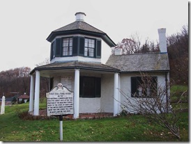
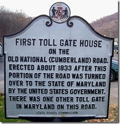
Marker Text: First Toll Gate House on the Old National (Cumberland) Road. Erected about 1833 after this portion of the road was turned over to the state of Maryland by the United States Government. There was one other toll gate in Maryland on this road.
Location: National Highway (U.S. Route 40) about six miles west of Cumberland, MD on the left when traveling west in the village of LaVale. Erected by the State Roads Commission.

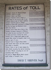
The only remaining toll house in Maryland along the Historic National Road Scenic Byway is located in LaVale. The restored Toll House has an original sign listing the prices charged for heads of cattle, hogs, and the like, commonly driven to market along the Pike.
Allegany County, Maryland has recently installed a park with covered pavilions and restrooms at the site and parking is available. The old toll gates can be viewed, as well as a remnant section of the National Road. The LaVale Toll House is listed on the National Register of Historic Places.
 The National Road was the Federal government's first experiment in public highway construction. Congress authorized the road's building in 1806 and by 1818 the road stretched from Cumberland, Maryland, to the Ohio River in what is today West Virginia. The length of the road from Cumberland to Wheeling was 132 miles, of which 34½ miles were in Maryland. The highest point on the National Road is the crest of Negro Mountain— 2,908 feet. From the time it was open to the public in 1818 until the coming of the railroads in 1852-53, the National Pike carried the bulk of trade, travel, and mails between the East and West. Due to the controversy about the national government's participation in public road construction, the project was halted until 1828.
On August 1, 1832 an army engineer from Cumberland reported, "I find the road in shocking condition. Some of it is now almost impassible." Congress turned over road maintenance to the states soon after and in 1835, Congress made their final appropriation of funds for repairs. To support the road the states established tolls and collected the tolls at established "toll gates". Maryland in 1833 constructed two toll houses to collect the tolls for road maintenance. I believe this marker covers the historical significance of the only remaining toll house on the National Road in Maryland. I attempted to find the location of the second toll house, which apparently no longer exists and could not found no references to its location. Maryland only needed two toll houses since only 34½ miles of the road were in Maryland and typically toll houses were placed 10 to 15 miles apart. Tolls were printed on a sign along the side of the toll house (see photo below).
Photo on the left is the list of toll rates on the side of the toll house.
Free travel was often permitted for going to or returning from public worship, funerals, military muster, mills, voting places, and business establishments.
I found some old photos of the National Road and this toll house taken about one hundred years ago or more. Here are some links to those photos, I am not sure of the dates of any of the photos, in the first photo link the roadway in front of the toll house is paved.
The second photo shows the Toll house and gives you a good idea of what the road looked like in early 20th century and the roadway is not paved.
Then the third photo, but it shows a less developed and earlier road than other photos, but you can see the toll gate posts on either side of the roadway.
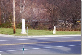
Photo on the right is taken across the road from the toll house and shows an old toll gate post and a mile marker (on right), indicating that the marker is 6 miles from Cumberland, MD.
In 1842, trains reached Cumberland, MD from Baltimore, as the rails were laid farther west, passengers preferred to ride behind locomotives rather than slow horses. The National Road was nearly abandoned after the railroad reached Wheeling, WV in 1853 and began to deteriorate due to loss of tolls. Travel over the old pike declined rapidly; inns closed and became farm houses. It had scarcely known any traffic for 40 years, until the advent of the automobile, then there came pleas for hard surfaced roads.
So the old road did not die. In 1916 Congress passed the Federal-Aid Road Act, designed to connect the State Highway systems into an articulated system of interstate highways. In 1925, the restored old National or Cumberland Road, was designated United States Route 40.
Today, there exists many historical markers along the old National Road celebrating the events and places which developed along the road. Markers about inns and taverns, bridges, toll houses, communities that developed and important events. Many of these I will share in future postings. Two prior postings of these markers included the “National Road (Called the Cumberland Road)” and “Castleman's River Bridge”.


No comments:
Post a Comment